Junta de Freguesia de Côta
- Parish council chair: Joaquim Polónio
- Address: Rua do Rego, n.º 2, 3505-237 Côta
- Opening hours: Wednesday, 18:00-20:00. Saturday, 14:30-16:30.
Find the Sanguinhedo school, in the largest parish in the municipality.
Chair, address, opening hours and contacts for certificates and voter registration.
Contacts and opening hours published by Viseu City Council and by the the parish council’s official website. Chair elected in the October 2025 local elections. Confirm before you travel.
Choose what you are looking for to go to the right section.
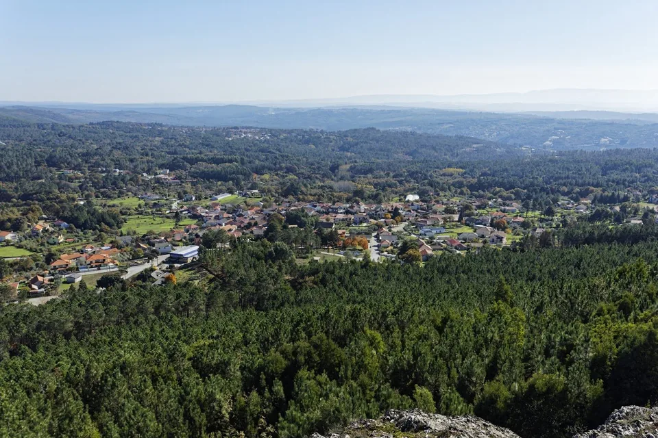
The least populous and the largest parish in the municipality, to the north. The school is in Sanguinhedo, about 26 km from the city.
The catalogue has no restaurant, café or supermarket with a pin in this polygon.
Escola Básica de Sanguinhedo de Côta belongs to Agrupamento de Escolas de Mundão and also offers preschool education. We have not confirmed a nursery in this parish. This list is not exhaustive; check current services with the parish council.
The municipal timetable has no line with a stop in this parish. Sanguinhedo das Maçãs is another service. By car, from the school, the Rossio is about 30 minutes away without traffic.
The seat is at Rua do Rego, no. 2. The door has no pin; the route starts at the Sanguinhedo de Côta primary school.
Check a walking route before setting off. Distance and time depend on your starting point; check pavements, gradients and crossings. The driving estimate below does not describe the walking route.
About 26 km and 30 minutes, without traffic, from the Sanguinhedo de Côta primary school to the Rossio.
The MUV timetable we publish does not name Côta or Sanguinhedo de Côta. Sanguinhedo das Maçãs is a stop on another line and in another parish.
Driving distance and time calculated along a real route (OSRM/OpenStreetMap) between the Escola Básica de Sanguinhedo de Côta (40.79742, −7.82254) and the Rossio (40.65720, −7.91390); approximate, not accounting for traffic. The parish council is at Rua do Rego, n.º 2, 3505-237 Côta, with no door-level pin. The school is in this parish and serves as the starting point for this comparison. Check the route before you set off.
The 25th parish in the municipality by population, the first by area, fourteenth in the rural area.
Côta has 796 residents in 41.55 km². It is the largest parish in the municipality and the fourteenth rural one, to the north, with the school in Sanguinhedo.
It went from 974 residents in 2011 to 796 in 2021. Density is 19.2 residents/km², that of a large and thinly populated area.
The Agrupamento de Escolas de Mundão runs the Escola Básica de Sanguinhedo de Côta here. Public 2nd and 3rd cycle schooling is in Mundão. The school group also lists it as a kindergarten.
The City Council points to the Pedralta megalithic necropolis and the São Salvador viewpoint and park. The map has a watchtower named São Salvador, which we do not publish as the viewpoint.
Population and change: Statistics Portugal, 2011 and 2021 censuses. Area: CAOP 2025, Directorate-General for Territory. Characterisation: Viseu City Council. School: OpenStreetMap, 40.79742, −7.82254. Consulted on 21 September 2026.
Pace, noise, traffic and services for anyone choosing a place to live.
In 41.55 km² live 796 people (19.2 inhab./km²). Between 2011 and 2021 it lost population (−18.3%). Côta is the largest parish (41.55 km²) and the least populated, in the north, in the rural heartland. By day the pace is that of the villages, the forest and the river Vouga. At night the stillness is the deepest in the municipality: there is no urban core. The parish council is open on Wednesday evenings and Saturday afternoons. It lost population markedly between 2011 and 2021.
Check connections to Côta with the operator. Distances within the parish are large; confirm current connections with the operator for each journey. MUV municipal routes reach Rossio and the hospital with fewer departures than the urban circuits.
Traffic is that of the municipal roads between the localities of Côta, in an area of about 42 km². There is no motorway or ring road. The City Council mentions ongoing investment in access roads and sanitation.
The parish council is at Rua do Rego, No. 2. There is no residents' permit zone or shopping centre car park. People park on the village streets and by the Miradouro e Parque de São Salvador.
There is no urban core, no street bars and no cinema. Nights in Côta are those of the villages and the forest.
The parish council is open on Wednesdays, from 6 pm to 8 pm, and on Saturdays, from 2.30 pm to 4.30 pm. There is the Escola Básica de Sanguinhedo de Côta, part of the Agrupamento de Escolas de Mundão. The hospital and the Loja de Cidadão are in Viseu parish.
The City Council points to the Necrópole Megalítica da Pedralta, the Miradouro e Parque de São Salvador, the Rota de Vale de Cavalos, mills, levadas and the landscape of the river Vouga. Choosing Côta means choosing this space, not Fontelo.
The hospital, City Council, tax office, Palácio do Gelo and bus station are in the city, to the south. With 41.55 km² and 796 residents, that journey is part of choosing to live here.
Editorial portrait of 13 September 2026. Population: INE, 2021 Census. Area: CAOP 2025, Direção-Geral do Território. Transport: MUV; municipal profile: Viseu City Council. Schools: DGAE, 2025/26 network. It is not a representative survey.
We have not confirmed a pharmacy, health centre, GNR station or CTT post office in this parish. This list is not exhaustive; check current services with the parish council. The parish council is listed at the top of this page.
The hospital, emergency department and on-duty pharmacies are in Viseu parish. We have not confirmed a nursery in this parish. This list is not exhaustive; check current services with the parish council.
OpenStreetMap search (pharmacy, school, place of worship, fuel and social facilities) checked against the CAOP boundary for Côta on 21 September 2026. We have not confirmed a pharmacy, family health unit, GNR station, CTT post office or petrol station in this parish. This list is not exhaustive; check current services with the parish council.
Escola Básica de Sanguinhedo de Côta also offers preschool education. We have not confirmed a nursery in this parish. This list is not exhaustive; check current services with the parish council.
Travessa da Escola, no. 9, 3500-435 Côta
Agrupamento de Escolas de Mundão. Listed as a primary school and kindergarten. The group's head school, with 2nd and 3rd cycle, is the Escola Básica 2,3 de Mundão, not included on this page.
There is no public 2nd cycle, 3rd cycle or secondary school in this parish. The head of the Mundão school cluster is in Mundão; the public secondary schools (Viriato, Alves Martins, Emídio Navarro) are in the parish of Viseu. Check catchment and places with each school.
State school network: DGAE, “School Clusters and Independent Schools Network 2025/26” (confirm programmes and education stages for 2026/27 with the school cluster); school belonging to Mundão school cluster (Travessa da Escola, n.º 9, 3500-435 Côta, 232 926 512). Map pin: OpenStreetMap, EM 566, 40,79742, −7,82254, which lists postcode 3505-237. Verified using a point-in-polygon test against the CAOP GeoJSON boundary for Côta on 21 September 2026. The school cluster lists it as a basic education school and preschool. We have not confirmed a nursery in this parish. This list is not exhaustive; check current services with the parish council.
The municipal timetable does not name this parish. The car covers the roughly 26 km to the Rossio.
No stop in the MUV timetable we publish is named Côta or Sanguinhedo de Côta. Sanguinhedo das Maçãs is on Line 17 and lies outside this polygon. We do not treat it as a service from here.
About 26 km and 30 minutes, without traffic, from the Sanguinhedo de Côta primary school.
Lines checked against the current municipal timetable, at /linhas-de-autocarro-muv/, on 21 September 2026. No timetable stop matches this parish. Sanguinhedo das Maçãs is on Line 17 and lies outside the polygon. We do not copy departure times: they change with the school term and with network revisions.
No restaurant with a pin in this revision. Pedralta and São Salvador stay on the City Council page, without a viewpoint pin.
The highest rated on Google.
We do not yet have restaurants confirmed in this parish. Where to eat in the city
For a coffee or a cake in this parish.
We do not yet have cafés or cake shops confirmed in this parish. Where to eat in the city
Where to shop in this parish.
We do not yet have supermarkets, mini-markets or greengrocers confirmed in this parish. Supermarkets in the municipality
The City Council points to the Pedralta megalithic necropolis, the São Salvador viewpoint and park and the Rota de Vale de Cavalos on the parish page. OpenStreetMap has a watchtower named São Salvador (40.80441, −7.83872), inside the polygon; it is not the viewpoint and it does not get directions. No confirmed filling station in this polygon.
Two short notes before you leave home.
The parish council is open on Wednesdays, from 18:00 to 20:00, and on Saturdays, from 14:30 to 16:30, on Rua do Rego. Counters change hours on public holidays. Always use the official link or the phone.
If a service has closed or a useful place is missing, tell us which one and give the source.
Last editorial review: 21 September 2026. This is an independent Olá Viseu page; it does not represent the parish council or the City Council.
See the transport, local services and walking guides too.
Population and 2011-2021 change from INE (2021 Census); boundaries from CAOP 2025; parish council, schools, transport and shops confirmed with Viseu City Council, the parish councils and Google Maps.